
Maps are never just pictures; they are claims on meaning and power, and when a head of state circulates an image that visually folds neighbors into his country, he is not changing borders but shaping the battlefield of interpretation.
The Short Version
- President Trump shared maps visually annexing Canada (and, in some variants, other neighbors), triggering fast, polarized backlash and official pushback from Canada and Mexico.
- The strongest evidence shows a recurring tactic: altered or AI-style cartography that signals dominance or rebranding rather than a formal policy directive.
- Reactions hardened into a miniature diplomatic incident because foreign officials answered a meme with policy-inflected statements of sovereignty.
- This sits in a broader Trump pattern of symbolic renamings and border imagery that rewards attention, regardless of whether critics read it as satire or provocation.
What actually happened: a president’s post, a visual annexation, and immediate pushback
Multiple outlets documented that Trump posted images depicting Canada as part of the United States—one with the American flag visually overlaying territory and another labeling a unified landmass “United States.” The coverage is consistent on the core artifact: an altered North America map that reads as annexation on sight, without footnotes or qualifiers. While the original Truth Social post is not recovered here as a primary-source capture, the convergence across reports is unusually tight for a meme-scale story, and the reaction record—especially among Canadian and Mexican officials—confirms how the images were perceived: as a provocation with geopolitical overtones, not a stray novelty graphic.
The domestic reception split along familiar lines. Critics labeled the maps “unhinged” or absurd; supporters cast them as trolling or theater. The important point is not whether the image was liked but what it did: it collapsed a boundary visually and dared audiences to read intention into the void. That invitation works because maps compress complex claims into a single glance; once seen, the artifact does the rhetorical work on its own.
Symbolic cartography: how the tactic works and why it travels
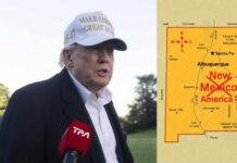
Cartography has always carried performative force—states print what they intend to defend or to normalize. A modern twist is the shareable, edited map: a graphic in which flags, labels, or color fills recode political geography without the messiness of legislation or treaties. Trump has leaned into this style repeatedly: posts renaming Lake Ontario as “Lake America,” a skirmish over “New America” in place of New Mexico, and region-scale overlays that imply U.S. reach from Greenland to the Caribbean. In each case the file is suggestive, not statutory; it signals ambition, dominance, or ridicule while preserving plausible deniability as satire or “just a post.” That is precisely why it is effective—and inflammatory.
In parallel episodes, mainstream and industry press characterized these graphics as symbolic gestures, often AI-styled or otherwise manipulated, that telegraph posture rather than policy. A Wall Street Journal live update, for example, described a Truth Social image draping the U.S. flag across Canada, Greenland, Venezuela, and Cuba, underscoring its expressive—not legal—character. Reuters likewise covered a downstream response as symbolic, reinforcing that observers with professional distance treated the map as messaging, not a boundary change.
Why allied governments reacted anyway
If the image was “just symbolic,” why did foreign officials respond? Because symbols do diplomatic work. A leader’s public visual annexation, even in meme form, sets a narrative that can harden if left uncontested. Canadian leaders answered in the language of sovereignty—Trudeau dismissed any prospect of absorption; opposition leader Pierre Poilievre echoed the point; Foreign Minister Mélanie Joly vowed Canada would not yield in the face of threats—thereby converting an online provocation into a formalized line in the sand. Mexico’s leadership parried with its own cartographic counter-symbol, invoking “Mexican America,” a rhetorical mirroring that denies U.S. narrative primacy and reframes the exchange as dueling claims rather than a one-sided joke.
This is classic signaling logic: when symbolism plausibly touches territorial status, silence can look like acquiescence. The fastest corrective is a statement that makes the sovereignty cost of the meme explicit and immediate. That is why these exchanges escalate quickly from social feeds to press briefings.
Where the evidence is strong—and where it is thin
The strongest elements of the record are threefold. First, multiple independent reports agree Trump shared maps that visually subsumed Canada into the United States; some iterations extended that overlay to other neighbors. Second, Canadian and Mexican officials issued on-the-record responses rejecting the implied claim. Third, the incident fits a documented pattern of Trump-era map provocations—renamings and overlays—described across mainstream outlets. These pillars together support a confident reading: this was deliberate symbolic cartography with predictable diplomatic friction.
The thinner elements are equally important to acknowledge. We do not have, in this packet, a timestamped primary capture of the exact post and caption; that limits forensic analysis of authorship, edit history, and intent. Nor do we have on-record White House or campaign staff clarifying whether the image was satirical, trial-balloon policy, or pure provocation. Finally, the AI-generation question surfaces in several reports but without a single, definitive technical analysis of the specific file at issue. Those gaps temper claims about motive or provenance but do not alter the observable effect: allied governments treated the images as a meaningful signal and responded accordingly.
🚨 New Mexico Dems are losing their minds because Trump posted a map crossing out “Mexico” and writing “America.”
Gov Lujan Grisham: “the name isn’t up for debate.”
Rep Stansbury: “Oh hell no.”He can’t legally rename a state.
He can troll the people who treat “Mexico” in the… pic.twitter.com/wywjXw3zul— Gina Beana Fofina (@Ginasassyass) September 7, 2026
The strategic logic: attention as the renewable resource
Why repeat these cartographic stunts? Because they deliver asymmetric returns. A single altered map does three things at once. It galvanizes a base that enjoys transgression and the spectacle of dominance; it forces critics and foreign officials to spend scarce attention and credibility rejecting something that is not, strictly speaking, policy; and it resets the agenda by flooding the zone with a vivid, screenshot-friendly artifact. Even denunciations amplify the image; the critique and the meme travel together. Media organizations, competing in an attention market, have strong incentives to package the artifact as controversy—“sparks backlash” is a near-automatic frame—further cementing the post’s reach and half-life.
How to read future map provocations without being played
A practical interpretive framework helps. First, separate the artifact from its implications: what exactly does the image depict, and is there any statutory or operational move attached to it? Second, look for the professional signals—agency directives, treaty language, executive orders—before imputing policy. Third, calibrate reaction to the most concrete component. If the map is only an overlay and the government remains silent on implementation, treat it as symbolic messaging; if agencies begin renaming databases, instructing contractors, or issuing procurement aligned to the image, you have crossed from theater to policy. This distinction matters because outrage is the fuel of this tactic; measured scrutiny is the brake.
The bottom line
Trump’s Canada-as-United-States maps were not cartography in any technical sense; they were claims on narrative space. The evidence supports a clear judgment: the posts operated as deliberate symbolic provocation within a now-familiar repertoire of renamings and overlays, and allied leaders were rational to answer them as such. Until or unless altered maps are paired with implementable authority—orders, budgets, agency action—they redraw attention, not borders. That does not make them harmless. It makes them strategic.
Sources:
mediaite.com, ladbible.com, thehill.com, yahoo.com, nytimes.com, reddit.com, inkl.com, newsweek.com, al.com, indiatoday.in
© conservativesense.com 2026. All rights reserved.